A Day Hike Adventure
on Mount Ulap
Eco-Trail

"Mt Ulap Eco-Trail ❌ is a day hike adventure along a 9.4 km mountain trail, a hiking time of 4-6 hours to Mt.Ulap summit passing Gungal in Itogon Benguet"


Day Hike Adventure on the
Eco-Trail to
Mount Ulap Summit
Mt. Ulap Eco-Trail, ❌ is a day hike adventure along a 9.4 km mountain trail, a hiking time of 4-6 hours to Mt. Ulap summit passing Gungal in Itogon Benguet
📌 Mt. Ulap is a unique day hiking trip for those who are looking to experience & Adventure the Cordillera Region Mountains.
✅ Whatever you are looking for,
the Eco Trail has it.
Mt. Ulap is technically the easiest to climb to the Summit.
You don’t need ropes or special mountaineering gear, or even any previous mountain climbing experience.

🚩 For Mountaineers and Adventurists “ain’t no mountain high enough” have used the mountains as a remedy for the stresses of modern life.

Arrival at Ampucao, Itogon Benguet
from
Baguio City
Registration at Ampucao Barangay Hall
📌 Forgotten for many decades, an old mountain path located high in the Cordillera Mountains snaking through this remote ancient mountain range which was only known to the mountain peoples and herdsmen who are living there.
✅ However, the most extraordinary thing was when in October. 31. 2015 a visionary Barangay of Ampucao has opened this ancient mountain path for hikers and call it Mount Ulap Eco-Trail a new era of Eco-Tourism for all ages was born for adventurers and hikers as we have known it today.

🚩 Ampucao, a small village in Itogon, Benguet, is nestled high up in the Cordillera Mountains of the Philippines, just 38km from Baguio City, the summer capital of the Philippines.

Totomtombek
Tourist Spot & Landmark
📌 We are still at the foothills of Mount Ulap Eco-Trail, and just a few minutes into the hiking path. Totomtombek is reached, and the first opportunity of a photo-taking souvenir is given.
✅ Totomtombek is not the place where archaeologists come to find ancient tombs or hidden treasures of the late GENERAL YAMASHITA nighter this is a destination for dinosaur's fossils and remnants of other species that we have not seen for millions of years.
🚩 In other words, there were no dinosaurs in the Philippines because, in the first place, there was no Philippines during the time of the dinosaurs. The Philippines came into existence as an archipelago about ten million years ago, during the Pleistocene Epoch. The first Philippine island likely surfaced nearly 60 million years ago – about five million years after the last of the dinosaurs died out.


Corral Rock outcrop
Tourist Spot & Landmark
📌 If you're coming to Corral rock and looking for a Sunrise scenario at early dawn, you are here right the location offers a fantastic day hike experience a breathtaking live view of the rising Sun over the Cordillera Mountains.
✅ In the desolate beauty along the Ampucao mountain range lies the Corral Rock.Due to its deferred location overlooking the Philex Road which the Corral rock formation rises from.
🚩 When the day displaces the night, and the last shadows pass, the people look up to the heights of the sunny Cordillera Mountain Range where the white eagle moves so lonely in the morning greeting the sun at dawn.
 depicts a normally dressed man wearing a dark blue coat and boots and steadying himself with a cane. He stands perfectly calm with his back to the viewer on top of the Corral Rock-outcrop. He looks at a gloomy landscape, far away from appearing mountain ridges of the Cordilleras, which are filled with white, puffy clouds, and the outlines of the mountain peaks of the Cordilleras, which are barely visible through the fog. In the distance ground, several other mountain ridges, perhaps not unlike the ones the wanderer himself stands upon, jut out from the mass. Through the wreaths of fog, forests of trees can be perceived atop these. ❌ Copyright © all rights with the author (Skr), @ 2015, Reimsbach, Germany.")

Ambanaw-Paoay Peak
Tourist Spot & Landmark
📌 Arriving on the highest spot on the Ambanaw Paoay 1st. Peak, you have a 360degr. around view of the Cordillera Mountain ranges on one side, you can see Mt. Arayat, Mt. Ugo, and Mt. Pulag along the horizon and with the Agno River up to the Pangasinan area
✅ The view of the other side is even more impressive.
🚩 There is a breathtaking panorama view of the massive Santo Tomas Mountain, a volcanic origin Mountain Ridges direct for the gates of the City of Baguio.
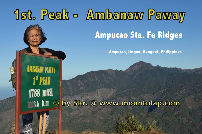
, @ 2015, Reimsbach, Germany.")
The Plateau
Tourist Spot & Landmark
📌 This Mountain Plateau is the halfway of your Mount Ulap Eco-Trail Hiking Tour
The Plateau is an exposed mountain rock. Due to the deserted and deferred rock location, you have a very clear view of the mountain city of Baguio both during the day and at night. Which is also known as the summer capital of the Philippines.
✅ You don’t even have to queue to capture that Insta-worthy photo of Baguio City, one of the Cordilleras' most famous Mountains City.
🚩 The Plateau is a big distinct rock formation and striking place, in fact, a massive place with endless possibilities for sightseeing, but there's no guarantee of seeing wildlife.
, @ 2015, Reimsbach, Germany.")
 near Gungal rock is a Rocky outcrop at the Ampucao Sta. Fe Range in Itogon, Benguet. with an approx. elevation of 1,450 m (4,757 ft) above sea level. ❌ Copyright © all rights with the author (Skr), @ 2015, Reimsbach, Germany.")
Schauinsland Rock
Tourist Spot & Landmark
📌 The summit of the Schauinsland is located at a 4.8km distance from the starting point.
The Schauinsland Rock outcrop (literally "look-into-the-country"; near Gungal rock is a Rocky outcrop at the Ampucao Sta. Fe Range in Itogon, Benguet. with an approx. elevation of 1,450 m (4,757 ft) above sea level.
✅ As the name says, here you have a 180degre panorama view of the Cordillera Mountain Ranges as well you can see Pangasinan and the Lingayen Gulf.
Due to its exposed location on the "Philex Road and Agno River" which the Schauinsland Rock outcrop rises from, there is a lot of strong wind, mainly from the south.
🚩 Over the course of many decades, this has led to unusual forms of Pine Trees with under need of combustible vegetation growing and the rapid spread of an uncontrolled fire is occurring in these areas every year.
, @ 2015, Reimsbach, Germany.")
, @ 2015, Reimsbach, Germany.")
Gungal Rock
Tourist Spot & Landmark
📌 Gungal Rock is the most popular hiking destination on the Eco-Trail way to Mount Ulap Summit.
🚩 Peoples come from far and wide many first-time travelers 🚶 visit the iconic Gungal Rock formation during their hiking tour on the Ampucao Sta. Fe Mountain Range.
On the highest spot on the Gungal Rock formation, you have a 360degr. around view of the Cordillera Mountain ranges on one side, you can see Mt. Arayat, Mt. Ugo, and Mt. Pulag along the horizon and with the Agno River up to the Pangasinan area.
✅ The view of the other side is even more impressive.
There is a breathtaking panorama view of the massive Santo Tomas Mountain, a volcanic origin Mountain Ridge direct for the gates of the City of Baguio.
, @ 2015, Reimsbach, Germany.")
, @ 2015, Reimsbach, Germany.")
Mount Ulap Summit
Tourist Spot & Landmark
📌 We Conquer Mt. Ulap Summit.
Two Senior Citizen Conquer ascending in a 6h hiking tour the Summit of Mount Ulap and finally reach the Summit Marker of Mount Ulap by rambling via the Ampucao Sta. Fe. Ridge, located in Itogon, Benguet, Philippines.
✅ There is a breathtaking panorama view of the massive Santo Tomas Mountain, a volcanic origin Mountain Ridges direct for the gates of the City of Baguio.
🚩 The highest peak on the Ampucao Sta. Fe Ridges with 1846 mASL was named ULAP after a preliminary Surveying was done by an Engineer name LAGMAN on Feb. 01. 1939.
 near Gungal rock is a Rocky outcrop at the Ampucao Sta. Fe Range in Itogon, Benguet. with an approx. elevation of 1,450 m (4,757 ft) above sea level. ❌ Copyright © all rights with the author (Skr), @ 2015, Reimsbach, Germany.")
Sta. Fe - Exit Point
Tourist Spot & Landmark
📌 Finally, we make it, arriving at the Exit Point in Sta. Fe after a 9.4km fascinating "Day Hiking Tour" on Mount Ulap Eco-Trail across the Ampucao Sta. Fe Mountain Ridge.
* hiking time: min-4h, max-8h
depending on your hiking speed
* distance from the starting point: 9.4km
* elevation of: 1,296 m (4252 ft) above sea level.
✅ Experience the breathtaking live view of the rising Sun over the Cordillera Mountains during Daybreak. From an engrossing sunrise to a thrilling sunset, from a rain-soaked to a mist saturate Day Hike whatever was your experience all of this Mount Ulap Eco-Trail has it.
🚩 At last but not least, going back to your home destination taken with you the Adventurist experience and the fascinating natural and cultural history visiting some of the most interesting historical sites, enjoy the invigoration that results from hiking with a local expert.
, @ 2015, Reimsbach, Germany.")
, @ 2015, Reimsbach, Germany.")
Transient House
near
Mount Ulap
Affordable & Budget-Friendly Accommodation
in Baguio City
near PMA, Loakan Baguio Airport,
Camp John Hay, Mt. Ulap
📌 After a day of exploring 🚶the Eco-Trail, what better way to reward yourself than by relaxing at a cozy Transient House
✅
🚩 Lety's ❌ Transient House near Mt. Ulap is the perfect place for families and groups of up to 40 guests.
, @ 2015, Reimsbach, Germany.")
🚩 Lety's ❌ Transient Homes in Baguio is a 28-minute drive from your destination, Mount Ulap Eco-Trail, and proudly calls itself a friend of the Eco-Trail.